Panorama Route, Mpumalanga: Every Waterfall, Viewpoint & Hidden Gem
Every waterfall and viewpoint from Sabie to the Blyde River Canyon — verified fees, drive times, and a working itinerary.
GeoParallaxFilmed & written on locationPanorama Route, Mpumalanga: The Ultimate Road Trip Guide
The Panorama Route from Sabie to the Blyde River Canyon — five waterfalls, God's Window, Bourke's Luck Potholes and the Three Rondavels, filmed on location in Mpumalanga.
The Panorama Route is a scenic mountain drive along the Drakensberg Escarpment in Mpumalanga, South Africa — a stretch of the R532 and R534 between Sabie, Graskop and the Blyde River Canyon where waterfalls drop off the Highveld, viewpoints open a kilometre above the Lowveld, and the world’s third-largest canyon waits at the end. After filming it waterfall by waterfall for GeoParallax, we can tell you the route rewards slowness. This guide covers every stop, what it really costs, and the quiet corners between the famous ones.
The route pairs naturally with Kruger National Park an hour below, drives fine in a standard car, and packs its highlights close together — no two major stops are more than about an hour apart. Below: how far it is, what it costs (verified fees), a working itinerary, the waterfalls at a glance — then every stop in driving order, exactly as our film runs.
Table of Contents
- How far is the Panorama Route from Johannesburg? (Distances & drive times)
- Can you do the Panorama Route from Kruger?
- What do Panorama Route attractions cost? (Fees, verified)
- A Panorama Route itinerary: how many days do you need?
- When is the best time to visit the Panorama Route?
- Is it safe to drive the Panorama Route?
- The waterfalls, at a glance
- The viewpoints, at a glance
- 1. Lone Creek Falls: The Route’s Swimmable Waterfall
- 2. Mac Mac Falls & Mac Mac Pools
- 3. Graskop & the Gorge Lift Adventure
- 4. The Pinnacle Rock
- 5. Lisbon Falls: Mpumalanga’s Highest
- 6. Berlin Falls: The Candle
- 7. God’s Window
- 8. Amber Treur Falls: The Quiet One
- 9. Bourke’s Luck Potholes
- 10. The Three Rondavels Viewpoint
- 11. The Blyde River Canyon
- Frequently Asked Questions
- Useful Links & Resources
- Our Photography Portfolio
How far is the Panorama Route from Johannesburg? (Distances & drive times)
Graskop is the route’s natural base — everything major sits within about an hour of it. From Gauteng, plan on a half-day drive: the N4 east, then up to the escarpment via Sabie or Lydenburg’s Long Tom Pass. Many travellers arrive from the other side instead, climbing up from Hazyview and the Kruger gates.
| Route | Distance | Driving time* |
|---|---|---|
| Johannesburg → Graskop | ±380 km | ±4 h 45 |
| Pretoria → Sabie (N4) | ±370 km | ±4 h 00 |
| Sabie → Lone Creek Falls | ±10 km | ±0 h 15 |
| Sabie → Mac Mac Falls (R532) | ±12 km | ±0 h 10 |
| Mac Mac Falls → Graskop | ±14 km | ±0 h 15 |
| Graskop → Pinnacle Rock (R534 loop) | ±5 km | ±0 h 10 |
| Graskop → God’s Window (R534) | ±9 km | ±0 h 10 |
| Graskop → Lisbon Falls | ±10 km | ±0 h 10 |
| Graskop → Berlin Falls | ±12 km | ±0 h 10 |
| Graskop → Amber Treur Falls | ±25 km | ±0 h 20 |
| Graskop → Bourke’s Luck Potholes | ±35 km | ±0 h 30 |
| Graskop → Three Rondavels Viewpoint | ±55 km | ±0 h 50 |
| Graskop → Hazyview (for Kruger’s gates) | ±40 km | ±0 h 40 |
*Approximate, without stops — and mind the potholes north of Graskop; they set the real pace.
Can you do the Panorama Route from Kruger?
Yes, and it is the usual pairing in reverse. Graskop — the route’s natural base — is about 40 km and 40 minutes up the escarpment from Hazyview, which is the town at Kruger’s southern gates, so the whole route is a comfortable day trip or a two-night detour from a Kruger stay.
Arriving from below changes nothing about the order of the stops: you climb to Graskop and drive the route from there exactly as the itinerary above sets it out, with everything major inside an hour of the town. The one difference worth planning for is health, not logistics — the escarpment route is malaria-free, while Kruger and the Lowveld beneath it are a low-risk malaria area. Check current guidance for the season you’re travelling.
What do Panorama Route attractions cost? (Fees, verified)
Gate fees are tiered by residency. At the four MTPA reserve gates a South African resident pays R32 to R80 a stop, SADC R37 to R91, a foreign visitor R69 to R173. Seeing all four in one day, the All Access levy undercuts paying gate by gate — R161 against R197 for South Africans, R385 against R427 for foreigners. The smaller waterfall gates run R15 to R25:
| Attraction | Fee (adults) | Notes |
|---|---|---|
| Lone Creek Falls | Small gate fee — cash | National Monument; pool at the base |
| Mac Mac Falls | ±R15 | Viewpoint; separate small fee at Mac Mac Pools |
| The Pinnacle Rock | R32 SA · R37 SADC · R69 foreign | Children R27 / R32 / R58; multiple viewpoints |
| Lisbon Falls | ±R25 | Mpumalanga’s highest waterfall |
| Berlin Falls | ±R25 | Viewing only |
| God’s Window | R37 SA · R43 SADC · R81 foreign | Children R32 / R37 / R58; Wonder View nearby is free |
| Amber Treur Falls | Free | No entrance fee; access via a dirt road off the R532 — needs a vehicle suited to unpaved terrain |
| Bourke’s Luck Potholes | R80 SA · R91 SADC · R173 foreign | Children R37 / R48 / R81; visitor centre, walkways; cards usually work here |
| Three Rondavels Viewpoint | R48 SA · R54 SADC · R104 foreign | Children R32 / R37 / R69; no longer free — carry cash |
| Graskop Gorge — entrance | R75 (child R37) | Official 2025/26 rates (to 30 Nov 2026) |
| Graskop Gorge — Lift & Forest | R205 (child R138) | Glass lift + forest walkways |
| Graskop Gorge — Zipline | R280 | Combo with lift +R150 |
| Graskop Gorge — Big Swing | R750 | 70 m freefall; video +R210 |
| Blyde Dam boat cruise | ±R390 | From Swadini side; pre-book |
| All Access day levy | R161 SA · R203 SADC · R385 foreign | Children R91 / R102 / R190; covers the whole Blyde River Canyon Nature Reserve for one day |
The Pinnacle Rock, God’s Window, Bourke’s Luck Potholes, the Three Rondavels and the All Access levy are the Mpumalanga Tourism and Parks Agency (MTPA) General Schedule of Tariffs, effective 12 December 2025 — the schedule carries no end date and is adjusted annually. Pensioners over 60 pay the child rate. Lone Creek, Mac Mac, Lisbon and Berlin are not MTPA reserve gates: those are locally collected fees, verified August 2026. Graskop Gorge Lift Company and Blyde Dam cruise prices are those operators’ own rates. Card machines are unreliable at the smaller gates, so carry cash in small notes.
A Panorama Route itinerary: how many days do you need?
Two to three days. The highlights fit into one very long day, but 2–3 days is the trip the route deserves, and the itinerary writes itself from the geography: waterfalls on day one, the viewpoint loop on day two, the canyon on day three. Filming it we found the stops are the point — rush it in a day and you see the route through a windscreen.
Day one, the waterfalls: Lone Creek Falls and a swim near Sabie, Mac Mac Falls and Pools on the way north, then Graskop for the night (and pancakes at Harrie’s). Day two, the big views: the R534 loop — Pinnacle Rock, God’s Window, Wonder View — then Lisbon and Berlin Falls, and the Gorge Lift or Big Swing back in Graskop. Day three, the canyon: Amber Treur Falls, Bourke’s Luck Potholes, the Three Rondavels Viewpoint, and if time allows, down to the Blyde Dam for the boat cruise before descending to Hazyview and Kruger.
When is the best time to visit the Panorama Route?
Year-round, with a real trade-off. The dry winter months (May–August) deliver the clearest, mist-free views — cold mornings, crisp light, and the escarpment edge actually visible. Summer (November–March) turns the scenery lush and the waterfalls thunderous, but brings the mist and rain that can close God’s Window like a curtain. Spring and autumn split the difference.
Whatever the season, check conditions before committing to the viewpoint loop — the escarpment makes its own weather, and mist can hide everything the route is famous for.
Is it safe to drive the Panorama Route?
Yes, with the local rules respected. The route is paved end to end and fine in a standard car, but potholes are a genuine hazard, especially north of Graskop — slow down and scan ahead. Don’t drive at night: visibility, animals on the road and security risks all worsen after dark, so plan every leg to arrive before sunset.
Watch for trucks, pedestrians and minibus taxis that stop without warning; lock the car and stow valuables before you arrive at viewpoints; and download offline maps — reception is patchy in the forests and gorges. Emergency numbers, nationwide: Police 10111 · Ambulance 10177 · From any mobile 112.
The waterfalls, at a glance
Five major falls sit within under an hour’s driving of each other — the greatest concentration of waterfalls in South Africa, and the reason the route exists at all. Two of them have water you can get into: Lone Creek at the base of the falls, and Mac Mac at the separate Pools two kilometres from the viewpoint. The rest are for looking:
| Waterfall | Height | Swimming? | From |
|---|---|---|---|
| Lone Creek Falls | 70 m | Yes — accessible pool at the base | Sabie, ±15 min |
| Mac Mac Falls | ±65 m twin cascade | Not at the falls — Mac Mac Pools 2 km away | Sabie, ±10 min |
| Lisbon Falls | 94 m — Mpumalanga’s highest | Pools below via a steep trail, conditions allowing | Graskop, ±10 min |
| Berlin Falls | ±80 m “candle” | No — viewing only | Graskop, ±10 min |
| Amber Treur Falls | Small cascade | No — hike down for the canyon views | Graskop, ±20 min |
The viewpoints, at a glance
Four viewpoints carry the route’s famous views, and three of them charge at the gate. The Pinnacle Rock and God’s Window sit on the R534 loop within ten minutes of Graskop; the Three Rondavels Viewpoint is fifty minutes north and is where you look into the Blyde River Canyon itself:
| Viewpoint | What you see | Fee (adults) | From Graskop |
|---|---|---|---|
| The Pinnacle Rock | A 30 m quartzite tower rising sheer from the Driekop Gorge forest | R32 SA · R37 SADC · R69 foreign | ±10 min |
| God’s Window | The escarpment’s edge — a drop of more than 900 m to the Lowveld | R37 SA · R43 SADC · R81 foreign | ±10 min |
| Wonder View | The same escarpment edge, and sometimes clear when the Window is misted | Free | Beside God’s Window |
| Three Rondavels Viewpoint | Three grass-capped peaks above the Blyde River Canyon | R48 SA · R54 SADC · R104 foreign | ±50 min |
Bourke’s Luck Potholes is the route’s other paid stop but reads as a geological site rather than a viewpoint — it has its own section below. Fees are the same MTPA schedule set out under what the attractions cost; the All Access day levy covers all of them.
1. Lone Creek Falls: The Route’s Swimmable Waterfall
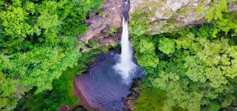
Lone Creek Falls, a declared National Monument fifteen minutes from Sabie, drops 70 metres down a sheer cliff face into a crystal-clear pool ringed by dense indigenous forest. The pool at its base is accessible, making it one of the very few Panorama Route waterfalls you can swim beneath — which is why we opened our film for GeoParallax here, and the one stop worth packing a towel for.
Our route begins here, where the grasslands of the Highveld meet the edge of the Great Drakensberg Escarpment. Well-kept pathways loop through the forest; give it an unhurried hour.
Tips for visiting Lone Creek Falls:
- The swim: the accessible pool at the base is a rarity on this route — bring a towel.
- Pathways: well-maintained and easy, through beautiful indigenous forest.
2. Mac Mac Falls & Mac Mac Pools
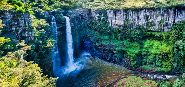
Mac Mac Falls, another National Monument, plunges 65 metres in twin cascades into a deep gorge ten minutes north of Sabie on the R532. The viewing platforms put you close enough to feel the water’s power; the plunge pool itself is off-limits. For the swim, drive 2 km to the separate Mac Mac Pools.
There a trail leads to clear rock pools made for families, with picnic and braai facilities alongside. The forest here is busy with vervet monkeys, chacma baboons and the southern yellow-billed hornbill.
Tips for visiting Mac Mac Falls & Pools:
- Swimming: only at Mac Mac Pools, never below the main falls.
- Hiking: a short trail descends toward the gorge; the 3 km Secretary Bird Trail starts at the Pools.
- Wildlife: keep food secured around the picnic areas — the baboons know the drill better than you do.
3. Graskop & the Gorge Lift Adventure
Graskop is the Panorama Route’s natural base — a small escarpment town with the route’s best access, everything major within about an hour, proper restaurants, and the institution that is Harrie’s Pancakes. Its headline act sits at the edge of town: the Graskop Gorge Lift Company, whose glass viewing lift descends 51 metres down the cliff face into the Afromontane forest below.
At the bottom, some 600 metres of elevated walkways and suspension bridges wind past streams and small waterfalls through genuinely pristine forest. Filming the gorge, that boardwalk loop turned out to be the quiet highlight — not the ride down.
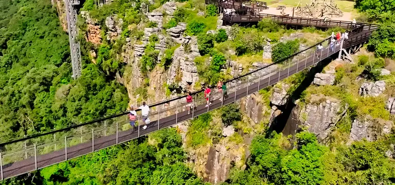
For the adrenaline-inclined, the gorge doubles as a playground: a 120-metre-high zipline across the void, the 70-metre freefall Big Swing (up to 140 km/h — you’ve been warned), and the high Cliff Walk along the gorge edge. Official 2025/26 rates: entrance R75, Lift & Forest R205, zipline R280, Big Swing R750 — see the fee table.
Tips for visiting the Graskop Gorge Lift:
- Booking: buy activity tickets online in peak season — the Big Swing sells out.
- Time: budget for the forest walkways, not just the ride down — the boardwalk loop is the quiet highlight.
- Weather: wind or storms can pause the swing and zipline temporarily.
- Facilities: restaurants, shops and restrooms on site.
4. The Pinnacle Rock
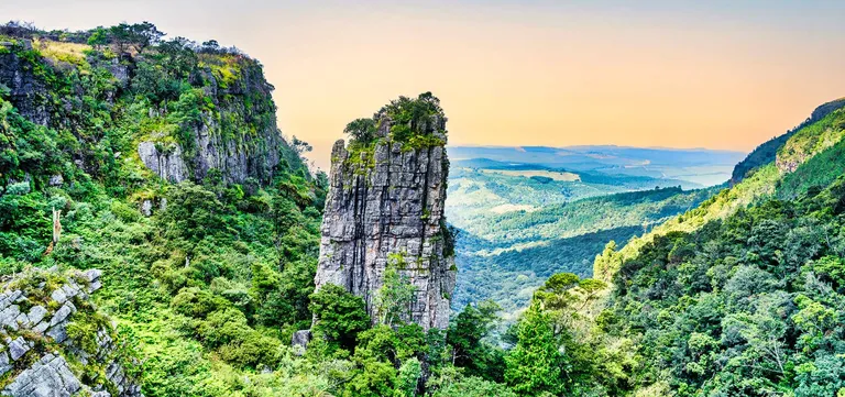
The Pinnacle Rock is a freestanding quartzite tower rising 30 metres sheer out of the Driekop Gorge’s forest, like a sentinel at the escarpment’s edge. Pathways link several constructed viewpoints, taking in both the rock and the small waterfall that threads through the stones beside it. We walked every one of them for the film, and the composition changes at each.
It sits a short hop onto the R534 loop; the surrounding grasslands open long views back across the formations. Scan the gorge forest for bushbuck, squirrels and impala.
Tips for visiting The Pinnacle Rock:
- Walk the loop: the different viewpoints genuinely change the picture — don’t settle for the first one.
5. Lisbon Falls: Mpumalanga’s Highest
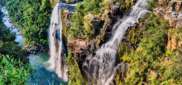
Lisbon Falls earns its superlative ten minutes north of Graskop: 94 metres of water in multiple cascades, the highest waterfall in Mpumalanga and one of the most spectacular on the route. The viewpoints near the parking area give the postcard angle; the steep trail into the gorge gives the reward — pools you can swim in below the falls, when conditions and access allow.
We loved the descent, with one honest caution: it’s steep, slippery after rain, and wants proper shoes. The gorge is superb for birds — African Fish Eagle, the elusive Narina Trogon, Grey Herons — with dassies sunning on the rocks.
Tips for visiting Lisbon Falls:
- The trail: assess conditions and your footwear honestly before descending — it’s worth it, prepared.
- Binoculars: this is the route’s best casual birding stop.
6. Berlin Falls: The Candle
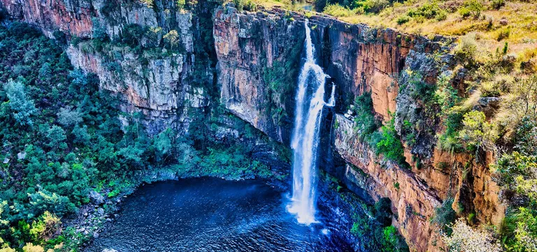
Berlin Falls drops 80 metres in a shape uncannily like a candle: the river narrows into a chute, then flares out below — the narrow wick above, the wax-melt spread beneath, landing in a deep, dark pool. This one is for looking, not swimming.
It is another ten-minute hop north. The clifftop pathways give bird’s-eye views of the falls and pool, and early morning light turns the pool luminous. In the surrounding grassland and forest, watch for the shy red duiker.
Tips for visiting Berlin Falls:
- The shape: look for the “candle” in the upper cascade before the main drop — it’s the picture everyone misses.
7. God’s Window
The name oversells nothing. At God’s Window the escarpment simply ends: the land drops more than 900 metres into forested ravines, and on a clear day the view runs across the Lowveld to Kruger National Park and, at the horizon, the Lebombo Mountains on the Mozambique border.
A paved path — steep in stretches — climbs through mist-fed rainforest to a series of viewing platforms along the edge, inside the greater Motlatse Canyon Provincial Nature Reserve. Filming it we lost a morning to mist and came back after the falls; conditions here change by the hour.
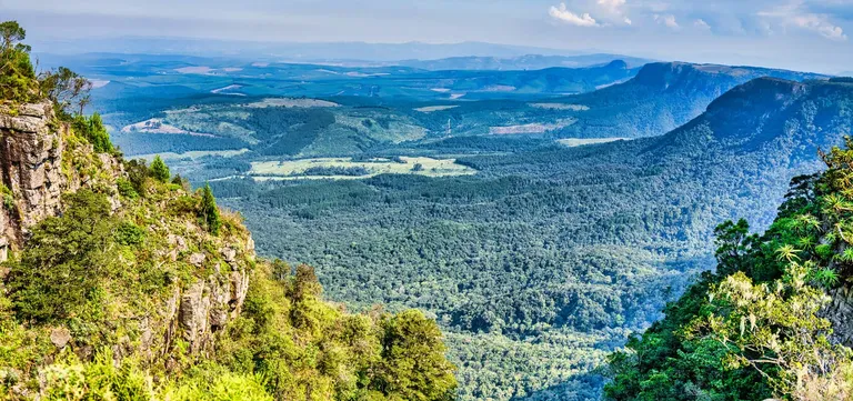
The one rule of God’s Window: check the weather first. The mist that feeds the rainforest can close the view completely — in which case the nearby Wonder View viewpoint, free and right off the parking area, sometimes catches gaps the Window doesn’t.
Tips for visiting God’s Window:
- Mist: if it’s socked in, don’t wait it out — do the falls and return; conditions change by the hour.
- The walk: paved but steep in places, through beautiful rainforest — allow 45 minutes to do it justice.
- Free alternative: Wonder View, moments away, costs nothing and needs no walk.
8. Amber Treur Falls: The Quiet One
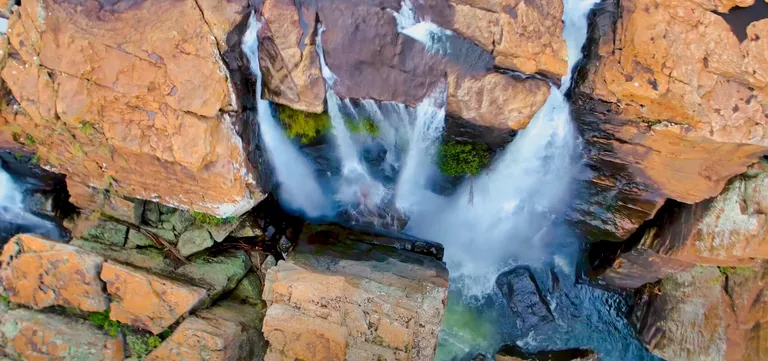
Amber Treur Falls is the route’s most peaceful waterfall stop — a scenic cascade on the Treur River (“river of sorrow” in Afrikaans, a name from the Voortrekker era), with none of the crowds of the headline falls. The reward for the short hike down toward the river canyon is having the views mostly to yourself.
It sits on the road toward Bourke’s Luck, via a turn-off that is part of why it stays quiet. There is no entrance fee, but the turn-off is a dirt road off the R532 and needs a vehicle suited to unpaved terrain. This is where our film slowed down; it’s that kind of place.
Tips for visiting Amber Treur Falls:
- Access: a dirt road off the R532, needing a vehicle suited to unpaved terrain — part of why it stays quiet.
- The hike: assess the path before descending; the canyon views below are worth careful feet.
9. Bourke’s Luck Potholes
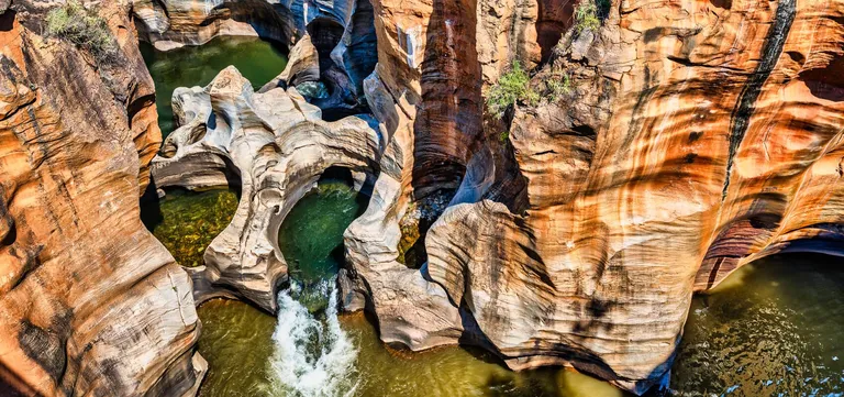
Bourke’s Luck Potholes is where the Blyde (“joy”) and Treur (“sorrow”) rivers meet and millennia of swirling, sediment-laden water have drilled the sandstone into a labyrinth of deep cylindrical potholes and sculpted channels. It is named for gold prospector Tom Bourke, who staked his claim here and famously never found gold in it.
Metal bridges and walkways hang above the swirling water, crossing red-and-yellow rock that looks deliberately sculpted. A visitor centre covers the geology; the site adds picnic spots and a craft market. It is the most developed stop on the route and the one we budgeted most filming time for — allow 1–2 hours. Toss a coin into the water for luck, the local tradition, and find the photo frame on the way out.
Tips for visiting Bourke’s Luck Potholes:
- Time: 1–2 hours minimum for the walkways, viewpoints and centre.
- Stay on the bridges: for your safety and the rock’s — the formations are fragile.
- Wildlife: rainbow-coloured lizards on the rocks, and keep an eye out for the blue-eared kingfisher.
10. The Three Rondavels Viewpoint
Three immense, round, grass-capped peaks rise from the wall of the Blyde River Canyon, shaped so like traditional rondavel huts that the name needed no inventing. From the official viewpoint’s fenced paths you look down the full sweep of the canyon as the Blyde River snakes toward the Blydepoort Dam far below.
It is the picture that captures the scale of Africa’s great green canyon better than any other single view — the signature image of the entire route.
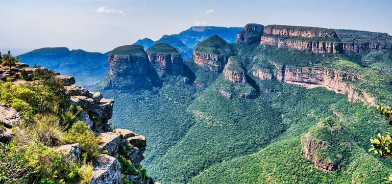
One update worth knowing about the official viewpoint: after years of free access, a gate fee now applies, tiered by residency — R48 for South African residents, R54 SADC and R104 foreign, with children R32, R37 and R69. Carry cash. It remains the route’s best value regardless.
The free roadside pull-over. There is a second way to see them. On the road toward the Blyde River Canyon, short of the official gate, a small unfenced pull-over looks straight across at the same three peaks — no gate, no fee, no facilities. The Rondavels are vast and visible from several kilometres out, and this is the spot we stopped at to film: to our eye it is the better view of the two. The photograph above was taken from its natural rock ledge, which is why there is no railing in it.
Tips for visiting the Three Rondavels Viewpoint:
- Light: afternoon sun bathes the Rondavels — the photographer’s hour, and the busiest.
- Walk the edge: at the official viewpoint, several vantage points along the fence line change the composition.
- Weather: like every viewpoint here, mist can erase it — pair it with Bourke’s Luck and choose your moment.
- Facilities: curio stalls and restrooms at the official viewpoint; nothing at all at the roadside pull-over.
11. The Blyde River Canyon
The route’s grand finale needs its numbers said plainly: the Blyde River Canyon is the third-largest canyon on Earth and the largest “green” one — over 26 kilometres long and up to 800 metres deep, its cliffs covered not in bare rock but in subtropical forest, within the Motlatse Canyon Provincial Nature Reserve. The viewpoints above give the scale; the canyon floor gives the life.
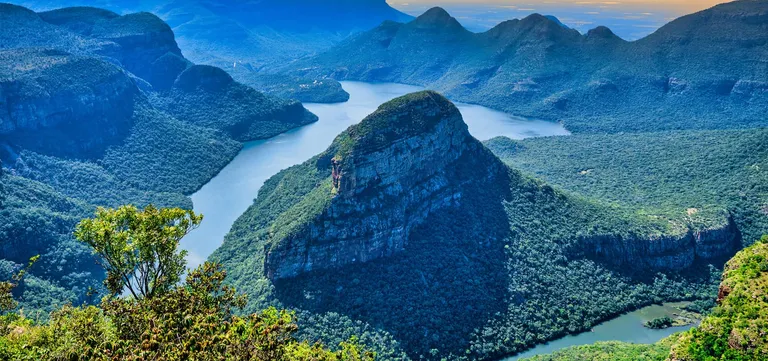
From the water, the Blyde Dam boat cruise (±R390, from the Swadini side — pre-book) looks up at the Three Rondavels and passes the rare Kadishi Tufa waterfall, with hippos and crocodiles for company. Hikers have the trails from the Blyde Canyon Forever Resort side — Leopard, Guinea-Fowl, Kadishi-Tufa; the adventurous have white-water rafting on the river and hot-air balloons above it. Birders, bring the long lens: everything from secretary birds to peregrine falcons hunts this canyon.
Tips for experiencing the Blyde River Canyon:
- The cruise: book the earliest or latest departure for the best light and fewest boats.
- Trails: check difficulty and access fees if you’re not staying at the resort.
- From above vs within: do both if you can — the Rondavels viewpoint and the dam cruise are two halves of one picture.
- Respect the reserve: marked trails only, litter out with you.
Useful Links & Resources
- Mpumalanga Tourism and Parks Agency (MTPA): mpumalanga.com
- Graskop Gorge Lift Company: Rates & booking
- Blyde Dam boat trips: Blyde Canyon Adventure Centre
- Blyde Canyon, A Forever Resort (trails): foreverblydecanyon.co.za
- Hot-air ballooning: Sun Catchers
- Kruger National Park (SANParks): sanparks.org
Guide fully updated August 2026. MTPA reserve gate fees and the All Access levy are the General Schedule of Tariffs, effective 12 December 2025, adjusted annually; Lone Creek, Mac Mac, Lisbon and Berlin are locally collected fees verified August 2026; Graskop Gorge Lift Company and Blyde Dam cruise prices are those operators’ own rates. They change often, so carry cash and confirm at the gates.
We hope this guide — the written companion to our film Panorama Route, Mpumalanga: The Ultimate Road Trip Guide — helps you plan a journey along South Africa’s scenic rooftop that goes beyond the famous viewpoints. Whether you’re here for the waterfalls, the sheer drop of God’s Window, the geology of Bourke’s Luck or the green immensity of the Blyde River Canyon, the Panorama Route delivers all of it — an hour above Kruger, and a world apart.
Now it’s your turn: drive it slowly, swim beneath a waterfall, and find your own favourite window on the Lowveld. Happy travels!
Our Photography Portfolio
The photographs in this guide were captured while filming our Panorama Route documentary. To license these images — or explore thousands more from nearly three decades behind the camera — find our portfolios on the major stock platforms:
- Shutterstock: Shutterstock Portfolio
- Adobe Stock: Adobe Stock Portfolio
- Getty Images / iStock: Getty Images Portfolio
Frequently Asked Questions
What is the Panorama Route, and where does it start and end?
- The Panorama Route is a scenic drive along the edge of Mpumalanga's Drakensberg Escarpment in South Africa, where the Highveld plunges into the Lowveld below. It runs roughly from Sabie and Graskop in the south to the Blyde River Canyon in the north, mostly along the R532 and the R534 viewpoint loop, threading together five major waterfalls, God's Window, Bourke's Luck Potholes and the Three Rondavels.
How many days do you need on the Panorama Route?
- The main highlights fit into one very long day, but we recommend 2–3 days: one for the waterfalls around Sabie and Graskop, one for the R534 viewpoints and Bourke's Luck Potholes, and time for an activity like the Graskop Gorge Lift or a Blyde Dam boat cruise. Base yourself in Graskop — everything major is within about an hour of it.
How far is the Panorama Route from Johannesburg?
- About 380 km — roughly 4½ to 5 hours' drive to Graskop, the route's natural base, via the N4 and Long Tom Pass or via Lydenburg. From Pretoria it's around 370 km and about 4 hours to Sabie. Most travellers make it a 2–3 day loop rather than a day trip, often continuing an hour down the escarpment to Kruger's gates.
When is the best time to visit the Panorama Route for good views?
- The dry winter months (May–August) offer the clearest, mist-free views, with cold mornings and evenings. Summer (November–March) brings lush scenery and the waterfalls at full power, but also the highest chance of mist and rain hiding the viewpoints — God's Window especially. Spring and autumn strike the balance.
What do Panorama Route attractions cost?
- Gate fees are tiered by residency. At the four MTPA reserve gates a South African resident pays R32 at the Pinnacle Rock, R37 at God's Window, R48 at the Three Rondavels and R80 at Bourke's Luck Potholes; SADC visitors pay R37, R43, R54 and R91, and foreign visitors R69, R81, R104 and R173. The All Access day levy covers the whole reserve for R161, R203 or R385 — less than paying all four gates. The smaller waterfall gates run about R15–R25. The Graskop Gorge Lift & Forest experience is R205, with the zipline at R280 and the Big Swing at R750 (official 2025/26 rates). Carry cash — card facilities are unreliable at the smaller gates.
Which Panorama Route waterfalls can you swim at?
- Lone Creek Falls near Sabie has an easily accessible pool at its base — the route's classic swim. The plunge pool at Mac Mac Falls is off-limits, but the separate Mac Mac Pools 2 km away are made for safe family swimming. At Lisbon Falls a steep trail leads down to swimmable pools when conditions and access allow; Berlin Falls is for viewing only.
Is it safe to drive the Panorama Route?
- Generally yes, with attention. Potholes are the main hazard, especially north of Graskop — drive cautiously and stay off the roads at night, when visibility, animals and security risks all worsen. Watch for trucks, pedestrians and minibus taxis that stop suddenly, lock the car at viewpoints, and keep valuables out of sight.
What is there to do on the Panorama Route besides the viewpoints?
- Plenty: swim beneath Lone Creek Falls, ride the Graskop Gorge Lift down into the forest, brave the Big Swing or the zipline across the gorge, hike the trails into the waterfall gorges, cruise the Blyde Dam beneath the Three Rondavels, go white-water rafting, or float over the canyon in a hot-air balloon.
Can you do the Panorama Route from Kruger?
- Yes. Graskop, the route's natural base, is about 40 km and 40 minutes up the escarpment from Hazyview at Kruger's southern gates, so the route works as a long day trip or a two-night detour from a Kruger stay. Arriving from below does not change the order of the stops — you climb to Graskop and drive the route from there, with everything major inside an hour of the town.
Can you combine the Panorama Route with Kruger National Park?
- Yes — it's the classic pairing. Kruger's southern and central gates lie about an hour below the escarpment via Hazyview, so most travellers do 2–3 days on the Panorama Route and then descend into the park. Note the health difference: the escarpment route is malaria-free, while Kruger and the Lowveld are a low-risk malaria area — check current guidance for the season you're travelling.